Rongorongo: Why Deciphering Easter Island’s Script Keeps Failing

On a small island in the far Pacific, a handful of wooden boards still refuses to give up its words. The script is called rongorongo, and for a century and a half people have tried to read it. Some claimed victory, others promised a breakthrough, a few announced full decipherments that later collapsed. Today, the tablets are as eloquent as ever, yet the message remains out of reach. This is not for lack of effort. It is because the conditions needed to crack a script—context, quantity, and comparison—were largely stripped away before scholars arrived.

What follows is the story of how those attempts faltered, and why the tablets keep their silence. Along the way we will look closely at the objects themselves, the reading order, the famous “calendar” passage, the hopeful claims, and the sober reasons they did not hold. It is, in short, a case study in why some scripts yield and others do not.

What rongorongo is (and what it might not be)

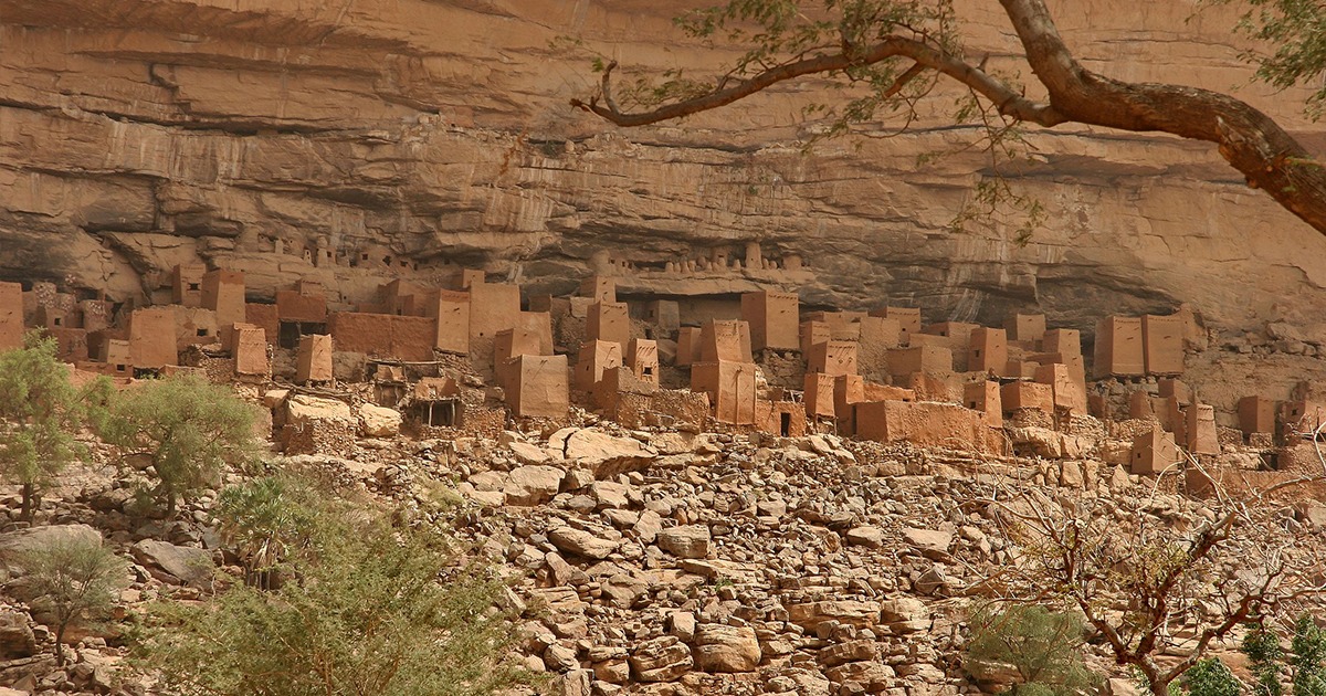
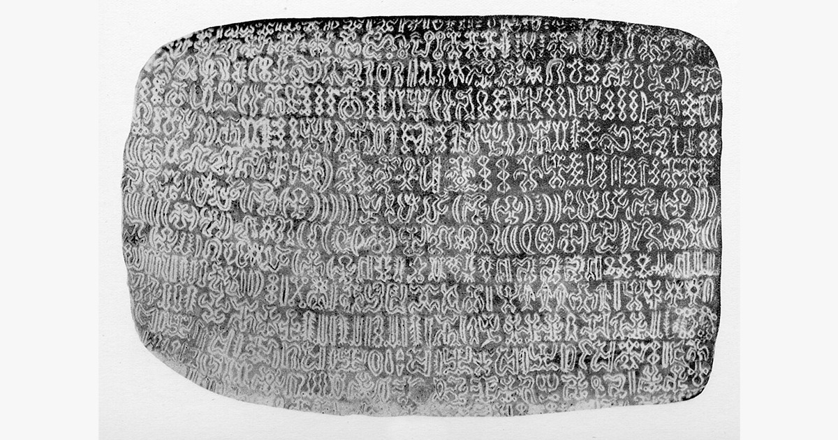
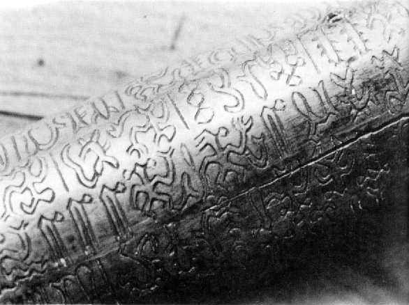
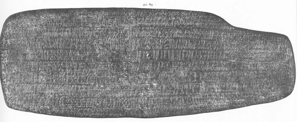
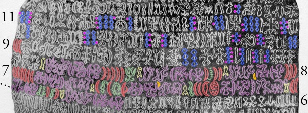
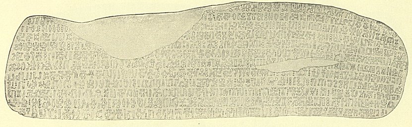
Rongorongo survives on a small corpus of wooden objects—mostly tablets, plus a staff, a reimiro chest ornament, and a few other pieces—inscribed with rows of tiny human, animal, plant, and abstract signs. The number of authentic inscriptions is commonly given as about twenty-six, scattered today in museums from Rome to Santiago and Berlin. That is a library so thin that every line matters. The script’s status is debated: some hold it to be true writing for Old Rapanui; others call it a mnemonic device for chants. Either way, it is a sophisticated system with strict order and excellent craftwork.

The carving is precise. Scribes incised the signs with great control and very few mistakes. They wrote in a distinctive pattern called reverse boustrophedon: the first line runs leftward; the next runs rightward with the glyphs turned 180 degrees; then left again, and so on. If you rotate the tablet at the end of each line, the text always reads left-to-right. That pattern is one of the few things everyone agrees on.

Close view of alternating lines on the Santiago staff showing reverse boustrophedon
Detail of the Santiago staff with alternating line orientation, a hallmark of rongorongo layout. Source: Wikimedia Commons

Discovery and loss, almost at the same time

The first outsider to note the inscribed tablets was the missionary Eugène Eyraud in 1864. Within just a few years, Bishop Tepāno Jaussen of Tahiti began collecting the boards as scientific curiosities, spurred by reports that such writing existed on Rapa Nui. During that same decade, the island suffered catastrophic raids by Peruvian slavers and the ravages of introduced disease. Communities were emptied, elders were lost, and with them, knowledge that had passed by memory. By the time the tablets reached museums, context was fractured and the reading tradition—if one still lived—had no safe ground on which to stand.

That is the first failure condition. Decipherment thrives on living memory, bilingual labels, or robust local explanations. Rapa Nui was denied those supports at the critical moment. What remained were remarkable objects, thin documentation, and stories that did not always agree.

The tablets themselves: what they show clearly

Each board is unique, yet several features repeat. Surfaces are planed and sometimes fluted. The signs, often a few millimetres high, sit in regular rows. On tablets such as the Mamari board and the two “Santiago” tablets, the carving is tight and consistent across long passages. Elsewhere, a staff carries lines that wind around the shaft, forcing the carver to adjust spacing and stroke. The visual discipline is striking. It suggests trained hands and standard habits down to the sequence of strokes within a single glyph.

These physical clues prove a system, not a casual scratch. But a system can encode many things: full language, numbers, names and titles, ritual prompts. The challenge is deciding which.

Recto of rongorongo Tablet B with long horizontal lines of glyphs
Recto of Tablet B (Aruku-Kurenga), a key text for sign counts and distribution studies. Source: Wikimedia Commons

How people tried to read them

Jaussen hoped to recover the key by asking an islander in Tahiti, Metoro Tau‘a Ure, to “read” the boards aloud. He dutifully recorded what Metoro chanted. The results—highly variable, often Tahitian rather than Rapanui, and mainly descriptions of what a glyph might depict—have long been judged unreliable for phonetic reading. They look less like text and more like free association or ritual gloss. As a guide to language values, they do not hold. As a glimpse of how someone might talk around the boards in the late nineteenth century, they are fascinating but inconclusive.

Later, scholars turned to comparison. The most influential framework came in 1958 from Thomas Barthel, who catalogued hundreds of sign types and assigned each a code. His sign list remains the reference. Statistical work since then suggests that many of those hundreds are variants and ligatures; counts in the range of a hundred-plus core signs are often cited. That is a plausible inventory for a logo-syllabic system, or for a compact set of mnemonic cues. Unfortunately, counts do not choose between those options on their own.

The famous “calendar”—and its limits

One passage is widely accepted as calendrical: a series on the Mamari tablet that maps a cycle of nights consistent with a lunar month. The sequence aligns with astronomical expectation and with Polynesian calendrical practice. It is the best-grounded match between a rongorongo text and a specific referent. Yet even here, we do not read the words; we identify the structure. The rest of the corpus has not yielded equivalently secure anchors, and without anchors, letters and sounds have nowhere to settle.

Highlighted sequence on the Mamari tablet interpreted as a lunar calendar
The well-known calendrical passage marked on the Mamari tablet, often cited as the strongest structural identification in the corpus. Source: Wikimedia Commons

High hopes and bold claims

Across the twentieth century and into the twenty-first, several researchers announced partial or full solutions. Some saw genealogies and ritual pairings in repetitive strings. Others proposed number words, phonetic complements, even entire reading algorithms. A few monographs attracted press, then met sustained criticism. The pattern is familiar from other undeciphered scripts: enthusiastic pattern-finding followed by sober counter-examples, with no consensus at the end.

What usually goes wrong? Proposals succeed on a few short lines and fail elsewhere. A value that fits here breaks the distribution there. A sign supposed to function as a phonetic element refuses to behave consistently in new contexts. Or the reading requires so much latitude—homophones on demand, wild polysemy, free alternations—that falsification becomes impossible. When a theory can always rescue itself, it has left the terrain of decipherment.

Why attempts keep failing: the nuts and bolts

1) The corpus is too small and too damaged. The surviving texts number only in the twenties. Several are fragmentary or badly worn. For a full phonetic decipherment, that is simply not enough material. Even Linear B needed hundreds of tablets and a lucky structural hunch to give way.

2) There is no bilingual, no long plain-text context. Rosetta-style helps are absent. We do not have a tablet beside a translation, nor a list of month-names beside festival scenes. Without such anchors, values drift.

3) Provenance is patchy. Many boards were collected after the reading tradition was broken, often with scant excavation records. We cannot place most tablets in precise ritual, social, or geographic contexts. Decipherment loves context; rongorongo lost it.

4) The sign inventory is tricky. Barthel’s list tallied ~600 signs, but many are variants. Narrower counts around a hundred-plus core types are plausible. That range could fit a syllabary, or a constrained set of logograms, or a mnemonic system. Statistics alone cannot decide, and mixed systems blur categories further.

5) The subject matter may be specialised. If the boards cue ritual recitations, lists of offerings, or initiatory names, their vocabulary will be narrow and repetitive. That is the worst case for decipherment: few topics, heavy formulae, and many proper names. You can fit multiple readings to such data without contradiction.

6) Late copies confuse the timeline. Radiocarbon dates on some pieces fall in the nineteenth century; at least one tablet has yielded a fifteenth-century date, suggesting deeper roots. A mixed horizon means scribal traditions may have changed—materials, conventions, even purposes—making the small corpus internally uneven.

Reading order and layout: one clear win

Although sound values remain elusive, layout is secure. The reverse boustrophedon format is not guesswork; it is obvious from the carving. So is line order: many tablets begin at a corner with neat margins, and the surface wear supports a standard sequence of handling. Scribal quality is high, with remarkably few corrections. This tells us that scribes followed well-learned patterns and copied with confidence. Unfortunately, perfect penmanship does not equal an alphabet key.

What modern imaging and new dates add

Recent documentation campaigns have produced photogrammetric models and high-resolution images of crucial tablets, improving readings of faint strokes and expanding sign counts on specific pieces. A tranche of radiocarbon tests has also complicated, and possibly enriched, the timeline. Some tablets cluster in the 1800s; at least one piece strongly indicates pre-European centuries. If authenticated across more objects, that suggests a tradition older than missionary contact, even if its late use was already rare or restricted. It supports neither easy “post-contact invention” dismissals nor any quick phonetic mapping. It does, however, justify continued, careful work.

The “why it mattered” question

Even without a reading, the script matters for cultural history. Rapa Nui produced a formal, island-wide system of incised signs used on valuable objects, with disciplined layout and trained scribes. That alone is extraordinary for a small, remote community. Whether the system mapped language line-by-line or cued specialised recitations, it encoded and protected knowledge. It also bound identity to material culture in a way that survived catastrophe. The tablets reached us because people valued them even when their words were fading.

Could a breakthrough still come?

It is not impossible, but any success will almost certainly be partial and incremental. Three paths look promising: first, exhaustive, transparent documentation of every stroke on every authentic object; second, careful statistical modelling that respects scribal variation and tests hypotheses across the whole corpus; third, deepening ethnographic and linguistic work with Rapanui oral traditions and Old Rapanui language, to tighten plausible semantic domains. A dramatic “aha” moment is unlikely. A slow drift from mystery to constrained understanding is not.

How to look at a tablet and see more

Stand before a good photograph and trace the rows with your finger. Watch the line flip and your brain flip with it. Notice how certain signs repeat in clusters, and how others serve as separators. Look for small corrections—rare but telling—that show a scribe catching an error. Then step back and imagine the board in a house or at a ceremony, handled carefully, perhaps chanted in company. That, at least, is something we can say with confidence: these boards were made to be seen and used, not simply hoarded.

Lessons from a failed decipherment

Rongorongo is not a failure; decipherment attempts are. The boards remind us that writing systems are not puzzles made for us. They are tools embedded in particular lives. When violence, disease, and removal smash the surrounding world, the tool may survive but the instructions do not. Scholars inherit beautiful fragments and do the best they can. Sometimes “the best” is an honest admission: here is structure, here are numbers, here is a likely calendar, and beyond that, we will not pretend to more than we know.

Why the tablets still move people

Because they do what portraits do: they place us near another mind. Not with a face this time, but with the evidence of deliberate marks laid in sequence by trained hands. Every line says, this mattered. In a museum case or an online image, you can feel that urgency. Even if the words never come back, the care is legible.

Recto of the Great Santiago tablet with broad, evenly spaced lines
One of the largest tablets, frequently reproduced in nineteenth-century facsimiles and modern studies. Source: Wikimedia Commons

In short

The decipherment of rongorongo has not failed from lack of imagination. It has failed because the tablets reached us almost naked of context, few in number, and cut off from a reading tradition already collapsing under outside pressures. We have a likely lunar passage, clear layout rules, improving documentation, and mixed but intriguing dates. We do not have the bilinguals, the bulk, or the continuity that give other scripts a fighting chance. That is a hard truth, but a useful one. It tells us where to spend our energy: on patient documentation, respectful collaboration with Rapanui knowledge holders, and careful, falsifiable proposals that touch the whole corpus rather than a single tempting line.

The Dogon Sirius Mystery: What Did They Really Know?

The Dogon of Mali live along a dramatic sandstone wall that runs for more than a hundred kilometres across the Sahel. Villages cling to ledges, granaries rise on stilts, and mask dancers turn courtyards into theatres of dust and song. For many readers, though, the first thing they hear about the Dogon is not the cliff or the masks. It is a claim about a star. The story says the Dogon knew that Sirius, the brightest point in the night, has an invisible companion and that the pair move around one another in a long, orderly cycle. That sounds impossible for a society without telescopes. It also makes for headlines. What happens when we slow down, read the sources, and listen to Dogon voices today.

Two paths run through this subject. One follows cosmology and ritual in a West African community that has held on to distinct practices for centuries. The other follows an argument in twentieth-century anthropology about field methods, interpretation, and how outsiders handle knowledge. Walk them together and the “Sirius mystery” turns from a simple puzzle into a fuller story about how ideas travel and change.

The land and the people

The Bandiagara escarpment sets the stage. It is a long cliff with shelves, caves, and high plateaux. It shelters villages from wind and gives easy watch over the plains below. Earlier peoples, the Tellem and the Toloy, left traces high in the rock. The Dogon moved into the area centuries ago and shaped a cultural landscape of houses, shrines, toguna meeting halls, and storage towers for millet. UNESCO lists the escarpment for its combined geological, archaeological, and living heritage, noting the continuity of ritual, architecture, and craft across the region. The site’s scale and depth make it one of West Africa’s most striking cultural terrains. :contentReference[oaicite:0]{index=0}

Daily life here carries strong rhythms. Farming follows the rains. Masks appear at funerals and large cyclical rites. Family compounds grow around courtyards. Granaries, male and female, store grain and personal goods, and their forms declare status and care. Houses and shrines use local earth, wood, and fibre, so the villages feel rooted in the cliff from which they rise. This setting frames the cosmology. Stars, seasons, and ancestors all belong to a single fabric of practice.

What the “Sirius mystery” claims

The popular version runs like this. The Dogon hold a complex cosmology that includes Sirius A, the bright star in Canis Major, and a hidden companion, sometimes called po tolo. According to the claim, po tolo is small, heavy, and moves in a long orbit, which modern astronomy describes for Sirius B, a white dwarf. The story links this to a grand festival, the Sigui, said to recur on a cycle connected to Sirius. Some writers add further details, or suggest a second unseen body, and a few leap to fantastical conclusions about extraterrestrial visitors. Those leaps often sell books, yet they do not help us understand Dogon thought on its own terms.

To unpack the claim, we need to ask where it came from, how it was recorded, and what later work found. That means meeting a handful of anthropologists and the debates their work sparked.

Where the idea comes from

French ethnographers Marcel Griaule and Germaine Dieterlen spent many seasons with Dogon communities in the mid-twentieth century. They published major studies of masks and ritual and, in 1950, a short paper titled “Un système soudanais de Sirius.” That piece set out a cosmological scheme in which Sirius and associated terms played roles in Dogon thought. Later publications elaborated this material, presenting an intricate chain of symbols, star names, and cycles. These texts shaped how outsiders talked about Dogon astronomy for decades.

In time, the work met scrutiny. Some astronomers and sceptics questioned whether the details were recorded accurately, or whether observers brought their own expectations to interviews. Others pointed to the risk of contamination. News about Sirius B had been public in Europe for years, and educated West Africans moved through trading towns and missions where such talk travelled. The question was not whether the Dogon looked at the sky, which they obviously did, but whether the specific claims about an invisible companion and its orbit truly belonged to Dogon tradition before outside contact.

What later fieldwork reported

In 1991, Walter E. A. van Beek published a long restudy that compared his years of fieldwork with the earlier French accounts. He found no general Dogon knowledge of the Sirius scheme as presented by Griaule and Dieterlen. Informants did not link the Sigui festival to an astronomical period for Sirius, and terms like po tolo appeared with other meanings, including a seed used as a symbol of smallness and density. The paper argued that the earlier system likely resulted from a unique field situation, particular informants, and strong guiding questions. The debate is sharp, but it remains the key reference for anyone writing about the Dogon and Sirius today.

Van Beek returned to the topic years later, reflecting on method and memory in Dogon studies. He described how prestige, translation, and the dynamics of a long research relationship can shape what ends up on the page. The result is a cautionary tale. Beautiful systems can emerge when an eager scholar meets a willing expert, yet community-wide knowledge may look different. For readers, this means treating the “mystery” as an argument about sources rather than a proof of secret science.

What astronomy actually says about Sirius

Sirius A is bright enough to fix its place in navigation and myth across continents. Sirius B is a white dwarf. The pair move around a common centre roughly every fifty years. Modern images, including those from the Hubble Space Telescope, show the faint companion near the glare of the main star. That is a difficult observation without instruments, so popular accounts often jump from “hard to see” to “impossible,” which is not quite the same thing as “unknown.” People can hear about things they cannot observe. Traders, teachers, and radio carried such talk across West Africa in the twentieth century.

None of this denies that the Dogon pay attention to the sky. It simply draws a line between a community’s sky-lore and a very specific scientific picture that belongs to modern astronomy. The two can meet. They can also pass by. Careful writing shows where each kind of knowledge stands.

The Sigui festival and the problem of cycles

The Sigui is a vast ritual cycle with processions, masked dances, and renewal of social roles. Outsiders often compress it to a single number, then map that number onto an orbital period. Real life is messier. Communities adjust timing to social and historical needs, and the festival can run over several years. Linking it cleanly to a precise astronomical clock looks neat on paper. It does not match the full range of practice reported on the ground. This is exactly where long fieldwork helps. It records variation and keeps us from forcing ritual life into tidy graphs.

Dogon cosmology on its own terms

Dogon thought is rich without any appeal to impossible knowledge. Myths remember a first world that fractured, a creative word that shaped matter, and the difficult task of keeping order. Ancestors and masks fold those themes into daily life. Crafts carry meaning. Carved doors and posts tell stories in short, repeating signs. Divination tracks the pale fox, whose prints mark chance and choice. In this frame, stars matter as part of a whole. They join winds, animals, and seeds in a network of correspondences that tie the cliff to the sky.

Consider the granary. Its round plan and thatched cap have clear functions, yet people also read it as a model of the world. Seed inside suggests potential. The door carries signs that speak of protection, fertility, and time. A cosmology that uses grain and sky together is not naïve. It is practical poetry, built from things at hand.

How myths travel and shift

Knowledge is social. Traders, soldiers, teachers, and tourists pass through the Dogon country. Mission schools once taught European astronomy. Radios carried news in French and Bambara. A striking idea can land in a village and find a welcome place within an existing myth. Over time, borrowed details settle into local terms. The result is not fraud. It is culture at work. This is how myths everywhere grow and bend, whether in Rome, Benin, or Bamako.

That is why scholars care about dates and contexts. A detail recorded in 1931 carries different weight from one taped in 1970. A statement from a single expert differs from one confirmed across several elders from different villages. These distinctions feel fussy to casual readers, but they protect against turning a conversation into a creed.

Reading popular books with care

The “Sirius mystery” jumped from scholarly journals to mainstream shelves in the 1970s. Popularizers joined the dots in dramatic ways, sometimes bringing in extraterrestrials or ancient visitors. Reviews at the time noted how much of this rested on the early ethnographies and how little cross-checking had been done. For students, these episodes are useful. They show how fast a neat diagram can outrun the footnotes. The lesson is simple. Read the field reports. Then read the rest with curiosity and caution.

The landscape that holds the story

It helps to step back and look again at the cliff. Villages and shrines draw a line between rock and plain. Paths thread along the base. Granaries, male and female, punctuate the skyline. UNESCO’s listing remarks on the interplay of architecture, ritual, and landform, which is exactly what a visitor feels. In recent years, conflict in Mali has strained local life and damaged heritage. International projects have worked with communities to stabilise buildings and safeguard ceremonial objects. Cultural survival needs both peace and patient repair.

When people discuss the Dogon, they often jump straight to the star. The place itself deserves the first look. A cosmology grows in a setting, and the Bandiagara landscape explains much about Dogon priorities. Grain must be safe from mice and rain. Paths must manage steep ground. Meeting halls must shade speech. In that daily work, myth breathes.

What we can say clearly

First, the Dogon have a deep, layered cosmology that runs through craft, ritual, and story. Second, the most dramatic claims about secret knowledge of Sirius come from a specific strand of mid-century ethnography and do not appear widely in later field reports. Third, modern astronomy confirms that Sirius has a white dwarf companion with a long orbit, and modern images make it visible near the glare of the bright star. Fourth, it is sensible to keep the categories straight. Sky-lore and science meet at points, but they answer to different rules of evidence.

These points leave space for wonder without short-cuts. They also leave room for Dogon knowledge to stand as Dogon knowledge, not as proof of an exotic theory. Respect shows in details, and in patience with sources.

Why the story endures

It endures because it is tidy, dramatic, and flattering to readers who want mystery in every corner. It also endures because the Dogon are genuinely compelling. Their masks, architecture, and rites have power. A star gives outsiders an easy way in. Our job is to make sure the path leads to the people and their place, not just to a talking point.

Besides, the real questions are interesting enough. How do communities anchor memory over centuries. How do rites absorb change and still feel old. How do crafts teach children what a myth means. These questions connect the Dogon to everyone else. The answers are written in wood, fibre, millet, and song.

Seeing and reading the Dogon well

Good visits begin with local guides and time. A morning at the base of the cliff teaches more than a week of headlines. Granaries tell their own stories. Masks come alive when you hear the rattle and feel the ground jump. A quiet hour in a toguna explains how shade and short roofs keep tempers cool. Photographs are welcome in some places and not in others, and permission is key. Even from afar, open collections and museum catalogues offer strong images and careful notes that help readers see the difference between temper and fact.

Once you have that foundation, the sky talk becomes easier to place. Sirius is a bright point with a well-understood companion. The Dogon see the same sky the rest of us do. Their cosmology makes different use of it, binding star and seed into a single fabric. That is not a failure of science. It is the mark of a culture that knows how to think across domains.

Dogon mask dance with tall headdresses performed on the Sahel plains near the cliff
Dogon mask dance in Mali, part of funerary and cyclical rites such as the Sigui. Source: Wikimedia Commons

Putting the “mystery” back in context

Strip away the hype and you have a useful case study in how research works. One team records a complex system. Another team returns and finds a different picture. The community itself changes as decades pass. Global media lift a few lines and make them carry more weight than they can bear. Readers step in at different points and pick the version that suits their taste. The antidote is straightforward. Compare field reports. Note dates. Weigh methods. Keep the landscape and the people in the frame.

When you do, the Dogon look even more impressive. The question is no longer, “How did they know a white dwarf orbits Sirius.” It becomes, “How did they hold a living ritual system together across hard seasons and hard years.” That is a real achievement, and it belongs to them.

Hubble image showing bright Sirius A with faint white dwarf companion Sirius B
Hubble Space Telescope view of Sirius A and Sirius B. The pair orbit each other roughly every fifty years. Source: Wikimedia Commons / ESA/Hubble.

Granaries, stars, and the scale of meaning

One last image helps. Imagine a farmer unlocking a granary at dawn. The roof keeps out rain and heat. The walls keep out mice. Inside lies the next month’s food and seed for the next season. For the Dogon, that small tower also holds meanings that reach beyond the village. A seed can stand for beginnings. A door carving can fix a promise. A pattern can remember a story. Stars enter that field of signs and lend it a wider horizon. The meeting of the intimate and the immense is not strange here. It is the way the world holds together.

Octagonal Dogon granary with thatched cap in a village at the foot of the escarpment
Classic Dogon granary on stilts. Granaries store grain and symbolise protection, memory, and potential. Source: Wikimedia Commons.

A measured ending

Call it a mystery if you like, but do not stop at the slogan. The Dogon give us a chance to see how people build meaning from land, craft, and sky. They remind us that stories travel and that careful listening matters. They also invite us to enjoy a night under the Sahel stars with good company, where the bright point of Sirius rises over the cliff and the village settles into quiet. The sky is old. The questions are too. The answers are richer when we let the people who live with them speak first.

Dogon village of mud houses and granaries near the base of the Bandiagara escarpment
A Dogon village near the escarpment, showing earth architecture and the close link between settlement and landscape. Source: Wikimedia Commons.

Malta’s Cart Ruts: Prehistoric Parallel Grooves That Puzzle Archaeologists

Across Malta and Gozo, pairs of parallel grooves slice the rock as if the islands were scored with a giant’s comb. Locals call them cart ruts. Archaeologists prefer a cooler label, yet the effect is the same. Everywhere the limestone lies bare, you find twin tracks that swoop, split, cross, and sometimes seem to vanish over a cliff. The puzzle is familiar and still unsolved. What made them, when were they cut, and why do so many run together in dense clusters?

The fascination comes from scale as much as mystery. Thousands of metres of ruts survive. Some pairs keep a steady gauge. Others widen or taper. A few dig so deep that you can stand in them up to your knees. One field in the south of Malta is so busy with crossings that a British archaeologist nicknamed it Clapham Junction. He was thinking of a railway yard, packed with tracks, points, and switchbacks. That image stuck because it fits the scene.

What the ruts are, in practical terms

Each rut is a channel cut into the bedrock. The two in a pair run broadly parallel, with spacing that hovers around the width you would expect from a two-wheeled vehicle or a sledge with twin runners. Depth varies from a shallow groove to cuts more than half a metre deep. Profiles differ too. Some ruts have a neat U shape. Others carry a sharper V, especially where the limestone is hard. At junctions the grooves braid and diverge. In places they climb slopes so steep you wonder what load could ever have been hauled there without slipping.

The rock matters. Malta is built from limestones of different character. The soft Globigerina beds weather quickly when wet, while the Coralline units resist wear. That variation helps explain why ruts deepen in one place and barely mark another. It also feeds the debate about formation. If wheels or runners bit into a wet surface, the softer layers would yield first. Over time, repeated journeys might turn a faint track into a channel deep enough to steer the next traveller without effort.

Where to see them

To grasp the pattern, start at Misraħ Għar il-Kbir on the edge of the Dingli cliffs. The field there holds hundreds of intersecting grooves. Some run straight for a surprising distance. Others veer and pivot, as if the route was adjusted mid-journey. The scale makes the point. This was not a casual scratch or a one-off procession. It was a working landscape put to use again and again.

Next, cut across to San Ġwann and the Mensija ruts. Here the grooves weave through a now-urban setting. Seeing them in a neighbourhood makes their persistence real. Builders stepped around them. Paths curved to accommodate them. They are heritage patterns that stubbornly outlasted changing plans.

On Gozo, the Ta’ Ċenċ plateau carries fine examples above sheer cliffs. The openness of that landscape lets you watch the ruts ride the contours and then vanish towards the edge. North-east on Malta, the Xemxija Heritage Trail preserves a Punico-Roman road segment with clear channels underfoot. These are later in date than some prehistoric candidates, but they demonstrate how rock tracks behave when used over time. They also show how later travellers adopted old habits whenever bedrock dictated the route.

How old are they

Dating is the hardest part. Most ruts lack secure archaeological contexts. Many were exposed long after their creation, when soil eroded away. Researchers use indirect clues instead. At a few sites, ruts appear to pass beneath tombs or walls of known date, which sets a latest possible period for their formation. At others, tool marks and finds from nearby features hint at a broad window from the Temple Period through the Bronze Age and beyond.

That wide range may be the real answer. The islands saw long use of the same outcrops. One generation might mark a route lightly. Another, centuries later, could deepen the grooves while repeating the same path. In wet winters the rock softens and tyre-like loads bite more readily. In drier spells the surface hardens and wear slows. The result is a palimpsest, carved and re-carved by people who cared more about moving goods than leaving a tidy pattern for us to decipher.

What made them: the main ideas on the table

Several hypotheses compete, and each has strong points. One camp argues for wheeled carts with a standard axle width. Under heavy loads, and especially when the bedrock was damp, wooden wheels could cut a little deeper each season. Another view prefers sledges on twin runners. Runners loaded with stone would slide better than thick wheels when clay and limestone turned slick. A third suggestion pushes away from transport altogether. On that reading some grooves are deliberate furrows laid out to manage water or to extend thin arable soils across stubborn rock. Others point to quarrying. Chiselled channels could guide blocks from a cut face down towards a waiting track or jetty.

Evidence overlaps. Where wear is smooth and symmetrical, rolling contact remains plausible. Where the contact zone shows sharper tool marks, a sledge or pre-cut guide trough makes more sense. The islands were busy. There is no rule that says a single method must explain every track in every place. What unites the ideas is friction, weight, and repetition. However the movement happened, it happened often enough to bite the stone.

Close view of deep parallel grooves with steady gauge at Misraħ Għar il-Kbir
Cart ruts at Misraħ Għar il-Kbir showing depth and spacing that suggest repeated use. Source: Wikimedia Commons

What the measurements tell us

Systematic surveys have compared widths, depths, and profiles across dozens of sites. The pattern is tighter than first impressions suggest. Many ruts cluster around similar gauges. Depths vary, but the relationship between depth and shape tracks rock type. Where the limestone softens easily, U-shaped channels predominate. Where it resists, sharper V profiles hold. This coherence hints at regular practice. People were not improvising every time they moved a load. They followed established routes and reused widths that matched their equipment.

Calculations based on ground clearance make an elegant point. Imagine a cart with a modest axle and large wooden wheels. On a slippery slope, once the grooves deepened to the height of the axle, the cart would bottom out. The driver would be forced to shift to a new line beside the old one. That behaviour neatly explains the clusters at sites like Clapham Junction. Grooves come in sets because old channels eventually became too deep to use. The result looks like a rail yard because the landscape is full of retirements and replacements.

Why the ruts cross and wander

Crossings seem chaotic until you picture traffic management without engineered roads. In fields and quarry zones people would have wanted options. If one line turned slick, they could switch to a neighbouring path. If a block cracked and needed to be dumped, they would pull to one side. Slight changes in destination compound the effect. Even when routes head broadly the same way, a few degrees of difference at the start produce crossings further on.

The shape of the land matters again. Ridges funnel movement. Shallow basins collect water and become traps. The ruts circumambulate those hazards. Where the ground tilts, tracks climb diagonally to soften the gradient, then swing back. A map of the field becomes a tuition in invisible constraints, written in stone.

Do any run into the sea

Some coastal sites show grooves on the foreshore that now dip into shallow water. Local reports and older notes describe ruts that once ran further across the rock before modern building or erosion took them. It is tempting to link these to lower sea levels in the past or to gradual tilting of the islands. Both ideas have logic. So does a simpler thought. Shorelines move even on human timescales. A few centuries of storm damage and rockfall can alter the edge enough to interrupt tracks that originally stayed dry. Whatever the mechanism, the sight of twin channels disappearing below the waves has fed the popular imagination. It shows how close daily work once ran to water.

What site names reveal

The most famous field sits by a complex of caves known as Għar il-Kbir, “the big cave.” The nickname Clapham Junction is shorthand among guides, but the Maltese name keeps the landscape anchored in its real setting. Elsewhere the toponyms speak about agriculture and quarries. San Ġwann’s Mensija ruts run through a zone of fields and garden walls. The Xemxija road carries pilgrim crosses carved on the rock, reminders that later travellers repurposed earlier infrastructure. On Gozo, Ta’ Ċenċ sits high above the sea, with long views that explain why routes collected there. Names underline habits. People used the same places again and again because the ground told them to.

Cart ruts running through a suburban setting at Mensija
Mensija cart ruts at San Ġwann, with modern streets and walls respecting ancient grooves. Source: Wikimedia Commons

Science at work on an old question

Recent studies have brought geomorphology to bear on the problem. Researchers test how quickly limestone weakens when wet, how loads distribute across narrow wheels or runners, and how slope and surface texture accelerate wear. They model the forces needed to produce observed depths within realistic timeframes. They also compare rut shapes across the islands to see whether the same types recur in different settings. Together these methods move the debate away from arm-waving towards numbers that can be checked.

Alongside this, archaeologists revisit old field notes and photographs. Some early excavations captured ruts partly buried under soil. Those records give a sense of how much erosion has changed the sites since. They also help tie particular grooves to nearby tombs, walls, and tool marks, which nudges the dating a little closer.

Transport, fields, or a bit of both

It may be fruitful to stop asking for a single answer. In a small island landscape, tasks crowd together. Quarrying, hauling, farming, and ritual passages could all mark the same outcrop at different times. A shallow groove used to channel run-off might have made a perfect guide for a sledge once the season turned. A block path cut to move stone might have doubled as a route for the heavy jars and amphorae that supplied a nearby site. When communities reuse the same ground for centuries, boundaries between functions blur.

The best approach is to read each field on its own merits. Does the rut emerge from a quarry face or aim towards one. Do grooves step neatly down a slope with consistent spacing, which suits controlled descent. Are there signs of chisel work within the channels. Do nearby features match a farmed landscape, such as small field systems and water management. Answers will differ site by site, and that is not a weakness. It is how living landscapes behave.

Twin grooves on the Ta’ Ċenċ plateau near the cliff edge
Cart ruts riding the contours on the Ta’ Ċenċ plateau, with a dramatic drop nearby. Source: Wikimedia Commons

Visiting well and reading the ground

The sites are open, windswept, and deceptively delicate. Bedrock shows wear from every modern footstep. Try to keep to obvious paths and avoid walking inside the deeper channels. After rain the rock turns slick and fragile. This is also when the ruts look their clearest, as water pools in the grooves and makes their pattern show. Early light helps. Shadows draw sharp lines that reveal intersections you might miss at midday.

Bring a simple checklist. Watch for a steady gauge between the grooves. Note where one pair widens or narrows. Look at the profile: U or V. Trace the route up and down the slope. Where does it choose to cross a ridge. Where does it dodge a shallow hollow that would hold winter water. In a few minutes you will find yourself reading a path from the point of view of the person who last hauled a load along it. That shift is the gift these sites offer.

Why the ruts matter now

They are not only a curiosity for guidebooks. They are part of a long story of work, habit, and adaptation. The tracks remind us that infrastructure does not always look like a paved road. Sometimes it is a pair of grooves that quietly steer a community’s labour across a rocky slope. They also act as a shared archive. Farmers, quarrymen, carters, and pilgrims left their mark in the same stone. The result is a common text written over centuries in a script that takes patience to learn.

For Malta and Gozo, the ruts form a thread that ties prehistoric settlement to later urban life. They cross parish boundaries and municipal zones without caring about them. They show how the islands’ geology shaped movement, how weather narrowed choices, and how people found efficient routes that we can still trace today. You do not need to agree on a single origin story to feel their importance. Standing in one of the deeper pairs and looking along its line is enough.

Rock-cut grooves on the Punico-Roman road at Xemxija
A Roman-period road segment on the Xemxija Heritage Trail preserves clear grooves from prolonged traffic. Source: Wikimedia Commons

Questions worth taking forward

Several lines of enquiry look promising. First, more fine-grained measurement. Cheap 3D scanning can capture rut profiles and depths at thousands of points, letting researchers compare sites precisely. Second, targeted excavation at the edges of fields where shallow soil still covers the rock. Finds trapped in that layer could fix dates for first use or latest reuse. Third, experimental archaeology that matches local limestone, reconstructed carts or sledges, and controlled loads. Trials on short test beds would show how quickly grooves form under realistic conditions.

There is also room for landscape history. Many tracks now end abruptly at modern walls or roads. Old aerial photographs and nineteenth-century plans can reveal how lines continued before development. In a few cases, geophysical methods might trace ruts where thin colluvium hides them. A joined-up map would help explain why routes favour one pass over another and how sets relate across hillsides.

A measured closing thought

These grooves do not need a single dramatic explanation to be worth our attention. Their power lies in accumulation. Step after step, wheel after wheel, runner after runner, they turned stubborn ground into a guide. The pattern looks chaotic from a distance. Up close it reads like sense, pressed into stone by people who knew exactly what they were doing. That is the part that lingers when you walk away. The island keeps its lines, and the lines keep their stories.

Meghalaya’s Living Root Bridges: Ancient Engineering That Grows Stronger

In the misty hills of Meghalaya, bridges are not only built, they are grown. Villagers in the Khasi and Jaintia hills train the aerial roots of the rubber fig into pathways that cross gorges and fast rivers. These living structures carry people, baskets, and stories. They need time and patience instead of cement. They do not rust. They do not burn. As the trees mature, the bridges deepen, thicken, and gain strength. It is engineering with sap rather than steel, learned by watching how roots search for soil and water.

The first sight can feel unreal. A span of interlaced roots, glossy after rain, pulls tight from bank to bank. Handrails twist upward like braided rope. Vines thread through gaps. Below, a river slides past boulders as big as huts. The bridge moves a little underfoot. It feels alive because it is. That sense of life, combined with practical toughness, explains why these crossings have endured in one of the wettest places on earth.

What a living root bridge is

A living root bridge begins with a rubber fig tree, Ficus elastica, growing close to a stream. The tree sends out aerial roots that hang like cords. Builders guide those roots across the water with patience and simple tools. The roots are pulled, tied, and sometimes threaded through a kind of natural pipe. As they thicken, they grip rock and soil and bind with one another. Over years the span becomes a footpath. In time it becomes a lane that can carry dozens of people at once.

Each bridge is a one-off, grown to fit a particular bend or slope. Some are single spans. Others stack into two levels like a double staircase in the air. A few form ladders or platforms. In shape and behaviour they echo modern types. You can read hints of suspension, arch, and truss. Yet they are made without drawings or machines. The design lives in memory and practice, passed down in families and villages.

Living root bridge connecting Mawlynnong and Nohwet villages
Mawlynnong’s Nohwet area. The span connects two villages across a narrow valley. The rail shows a mix of young green roots and older brown wood. Source: Wikimedia Commons

How people grow them

The core method is straightforward. Builders plant or select rubber fig trees on both sides of a stream. Young roots are coaxed across using guides. Hollowed trunks of areca palm or lengths of bamboo act like conduits. Roots are threaded through these channels so they remain straight and protected while they reach the far side. Once a root touches soil, it thickens and anchors. More roots follow and are woven into the span.

Maintenance is part of the craft. New roots are trained in, weak roots are pruned, and loose fibres are tied back into place. Storms can tear at edges, so people walk the bridges after heavy rain and repair what needs attention. The work is quiet, small in scale, and continuous. Instead of heavy labour for a few months, the bridge asks for light work most years.

Time as a building material

These crossings are not instant. A young bridge might take a decade before it feels safe. A mature bridge can carry crowds. Age is not a threat here. It is an asset. As roots grow they thicken and fuse, a process called inosculation. The wood becomes a lattice that behaves like a bundle of cables locked together. The longer the bridge lives, the more paths the forces can take. Where a plank bridge grows tired under load, a root bridge often gains options.

Time also makes the path more comfortable. Early spans feel springy and narrow. With growth, the surface smooths and the handrails settle. Moss fills gaps. Local people add stone pavers and gravel to flatten the tread. The result is a walkway that looks rustic but feels secure.

Why they work in this landscape

Meghalaya’s southern escarpment catches monsoon clouds. Rain comes in sheets. Rivers rise fast and drop just as quickly. Metal bridges corrode. Timber rots. Concrete can wash away where foundations are poor. A living root bridge rides out this chaos. Roots grip rock. The span flexes slightly when floods push debris against it. If a section fails, fresh growth can be trained to replace it. The system adapts because the material adapts.

The trees help beyond the span itself. Their canopies shade the stream, cooling water and slowing evaporation. Root mats stabilise banks and limit landslides on steep paths. Birds nest in the crown. Bees find flowers in the dry months. The bridge is not just a crossing. It is a piece of woodland that happens to carry people.

Jingmaham living root bridge at Riwai near Mawlynnong
Riwai–Mawlynnong area. A classic span with braided handrails and a packed footway. Maintenance keeps new growth aligned and the walking surface even. Source: Wikimedia Commons

Knowledge held in common

The Khasi and Jaintia communities treat bridge making as shared practice. No single person “owns” the method. Villages agree on maintenance. Families teach children how to spot a healthy root, when to guide a shoot, and how to tie a splice that does not choke growth. Work parties clear paths and repair handrails at the start of the wet season. When visitors arrive, a local guide often keeps walking time steady and discourages crowding on delicate spans.

That shared care shows in the way bridges age. Some crossings have been tended for many generations. Others fell from use when a path changed and the village moved. You can still find ghost bridges in the forest such as twisted masses where rails outgrew the track. They remind people that living structures need living attention.

Forms, sizes, and famous examples

Many visitors know the double-decker near Nongriat. Two tiers cross a boulder-choked stream under a curtain of rainforest. The lower span came first, then the upper. In other valleys you can find single spans that stretch far across a torrent, and compact bridges tucked into narrow ravines. A handful of bridges run to lengths that surprise even seasoned walkers. In the Pynursla region, some spans approach the width of a small road when measured at the crown of the root mass.

Each site asks for a different approach. On a steep slope, builders bias the weave to one side so the bridge sits level when loaded. Where the river breathes wider in flood, they plant flexible rails that can yield and recover. Over rock shelves, they anchor roots into natural cracks. The result is a collection of structures that look related yet never repeat exactly.

Material science in the forest

Study a bridge with an engineer’s eyes and the tricks become clear. Aerial roots behave like cables in tension. Where they cross and fuse, they act like joints. The mass of roots at the banks works like an abutment. Add stones on top and you get weight that improves stability and comfort. Because the system can grow and change, it handles stress differently from fixed materials. If one path is overloaded, growth can reinforce it over time. The bridge tends toward redundancy, which is a fine quality in a place that sees cloudburst rain.

Microscopy shows why the material performs well. Root tissues lay down new wood each season. Fibres align along the direction of stress. When two roots press together, their cambium layers can merge. That creates a natural splice which slowly strengthens with each growth ring. It is not magic. It is biology working with gravity and load.

Close view of aerial roots of a rubber fig tree
Aerial roots of Ficus elastica. These cords begin as fibres no thicker than a finger. With training and time they knit into strong, load-bearing members. Source: Wikimedia Commons

Culture, story, and everyday use

For local people these crossings are part of the day’s work. They link farms and schools. They shorten a journey to market. They provide safe routes in a land of slick stone and sudden streams. Children learn to cross them early. Elders set the pace and choose when to rest. The bridges support rituals too. Festivals and family events often require visits to relatives across the valley. A sound bridge makes those visits possible when the rain is at its heaviest.

Stories cluster around particular spans. Some tales recall first builders who planted trees as newly married couples and saw the bridge ready for their grandchildren. Others speak of repairs after a violent flood. These accounts are practical and proud. They record who cares for a place and how a community solves a shared problem.

Recognition and protection

There is growing interest in formal recognition. Cultural bodies and conservation groups have proposed the living root bridge landscapes for heritage status. The argument is simple. These crossings combine indigenous knowledge, ecology, and engineering in a way that few other traditions match. Workshops, exhibitions, and field studies now collect data on locations, conditions, and needs. The aim is to protect the practice as well as the bridges.

Local government programmes have also begun to support documentation and careful tourism. Some funds go to path repair and signage. Some support training for guides and maintenance teams. The hope is to keep bridges open for villagers first, while giving visitors a way to see them without harm.

Living root bridge in the Cherrapunji region
A living root bridge in the Cherrapunji belt. The walkway shows how young roots are woven into the span while older wood supports the load. Source: Wikimedia Commons

Seeing the bridges well

Footwork matters here. Trails are steep. Stone steps can run for thousands in a single journey. In wet weather, the rock sweats and grips unevenly. Walk with patience. Keep the group small on the span. Let people pass who carry loads. Do not poke fresh roots or pry at ties. If you stop for a picture, step to one side and keep an eye on your footing. A good walk feels better when it ends without slips.

Guides often share small details that deepen the visit. You may learn how to spot a healthy cambium. You may see a young root threaded through a palm trunk, the channel acting like a mould. You might notice a rail that looks green in one section and brown in another. That is age talking. New growth darkens as it thickens. It is the bridge telling you it is still at work.

Lessons for modern design

These structures challenge habits. Modern building splits roles into design, construction, and maintenance. Here, those roles blur. The plan is a memory. The construction lasts years. The maintenance is growth. The bridge is a process more than a product. Designers who care about climate and material cycles can learn from that. Building with time and care rather than scale and speed will not suit every need, yet it offers a clear alternative in the right places.

There is also a lesson in redundancy and repair. A living span expects to change. It builds safety by adding more paths for force to travel. It assumes someone will check it after a storm. It rewards steady attention. Those are healthy assumptions in any system, whether a bridge, a farm, or a city’s drains.

The future of a living craft

The bridges are resilient, yet they are not invulnerable. Roads pull travel away from footpaths. Some villages find fewer young people available for maintenance. Heavy tourism can crowd spans and wear approaches. Thoughtful planning can answer these pressures. Clear routes spread footfall. Capacity limits protect delicate sites. Community funds pay for steps and handrails without changing the character of the place.

Schools that teach the craft keep it alive. Field days where children help thread a young root plant a seed of pride. Short films and exhibitions share the method with neighbours who might revive an old path or start a new one. The idea travels, but the heart of it remains local: a village, a tree, a stream, and time.

What to remember

Stand on a root bridge and you feel a different clock. Your foot meets wood that began as a hair-thin thread. Someone guided that thread years ago. Someone else will tend it next season. In a world that prizes speed, it is good to cross a river on patience. The span below you shows what happens when a community works with a tree rather than against it. The crossing is quiet, strong, and kind to the valley that holds it.