The Dogon Sirius Mystery: What Did They Really Know?

The Dogon of Mali live along a dramatic sandstone wall that runs for more than a hundred kilometres across the Sahel. Villages cling to ledges, granaries rise on stilts, and mask dancers turn courtyards into theatres of dust and song. For many readers, though, the first thing they hear about the Dogon is not the cliff or the masks. It is a claim about a star. The story says the Dogon knew that Sirius, the brightest point in the night, has an invisible companion and that the pair move around one another in a long, orderly cycle. That sounds impossible for a society without telescopes. It also makes for headlines. What happens when we slow down, read the sources, and listen to Dogon voices today.

Two paths run through this subject. One follows cosmology and ritual in a West African community that has held on to distinct practices for centuries. The other follows an argument in twentieth-century anthropology about field methods, interpretation, and how outsiders handle knowledge. Walk them together and the “Sirius mystery” turns from a simple puzzle into a fuller story about how ideas travel and change.

The land and the people

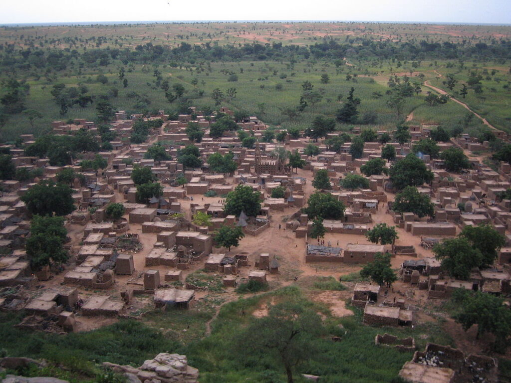
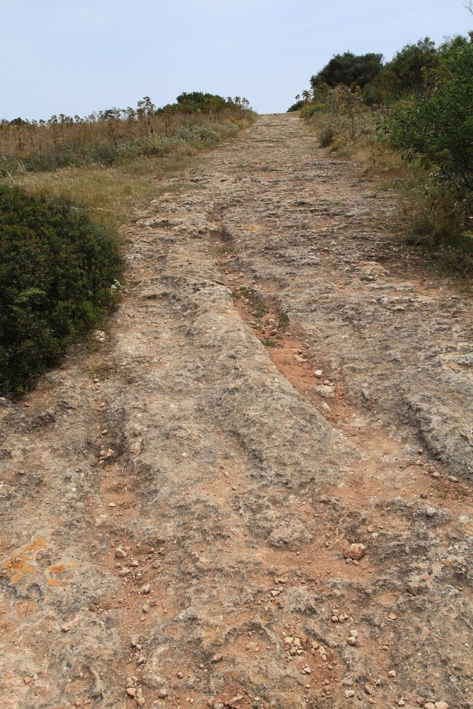
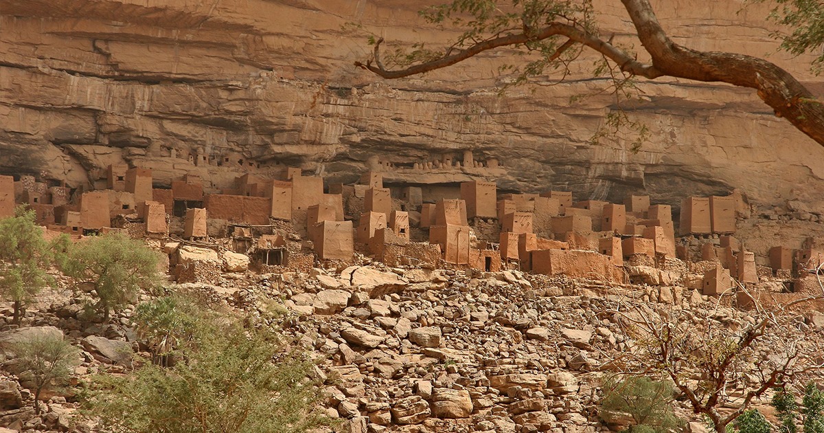
The Bandiagara escarpment sets the stage. It is a long cliff with shelves, caves, and high plateaux. It shelters villages from wind and gives easy watch over the plains below. Earlier peoples, the Tellem and the Toloy, left traces high in the rock. The Dogon moved into the area centuries ago and shaped a cultural landscape of houses, shrines, toguna meeting halls, and storage towers for millet. UNESCO lists the escarpment for its combined geological, archaeological, and living heritage, noting the continuity of ritual, architecture, and craft across the region. The site’s scale and depth make it one of West Africa’s most striking cultural terrains. :contentReference[oaicite:0]{index=0}

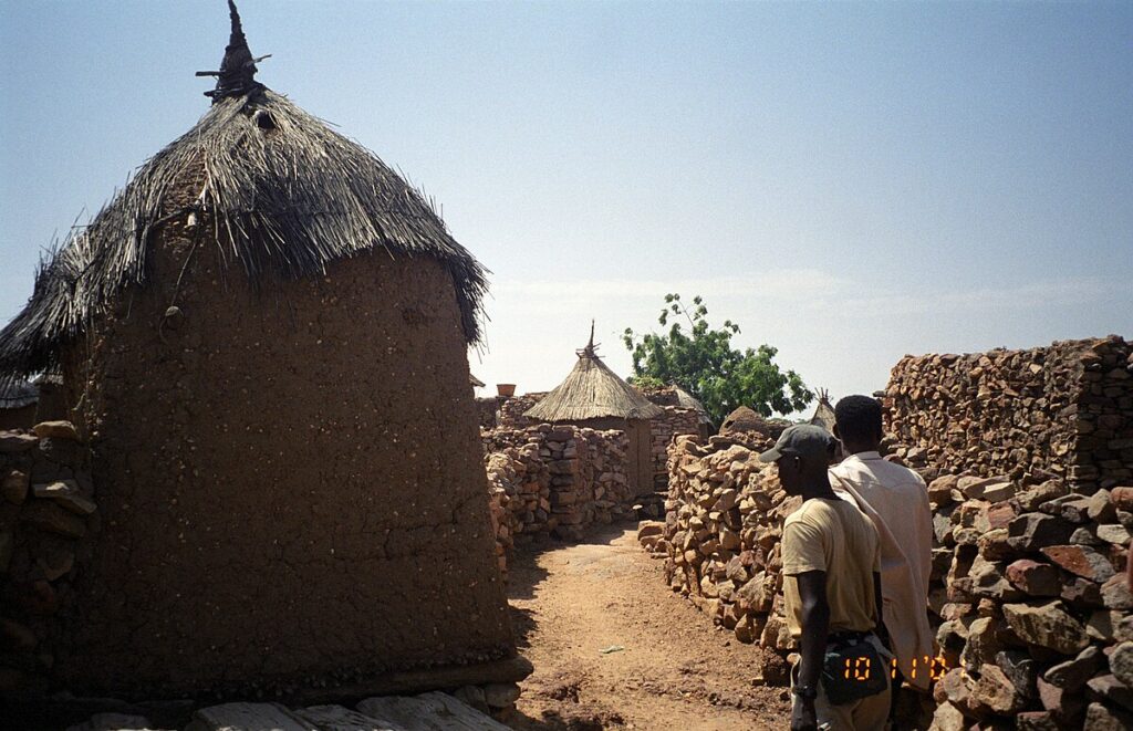
Daily life here carries strong rhythms. Farming follows the rains. Masks appear at funerals and large cyclical rites. Family compounds grow around courtyards. Granaries, male and female, store grain and personal goods, and their forms declare status and care. Houses and shrines use local earth, wood, and fibre, so the villages feel rooted in the cliff from which they rise. This setting frames the cosmology. Stars, seasons, and ancestors all belong to a single fabric of practice.

What the “Sirius mystery” claims

The popular version runs like this. The Dogon hold a complex cosmology that includes Sirius A, the bright star in Canis Major, and a hidden companion, sometimes called po tolo. According to the claim, po tolo is small, heavy, and moves in a long orbit, which modern astronomy describes for Sirius B, a white dwarf. The story links this to a grand festival, the Sigui, said to recur on a cycle connected to Sirius. Some writers add further details, or suggest a second unseen body, and a few leap to fantastical conclusions about extraterrestrial visitors. Those leaps often sell books, yet they do not help us understand Dogon thought on its own terms.

To unpack the claim, we need to ask where it came from, how it was recorded, and what later work found. That means meeting a handful of anthropologists and the debates their work sparked.

Where the idea comes from

French ethnographers Marcel Griaule and Germaine Dieterlen spent many seasons with Dogon communities in the mid-twentieth century. They published major studies of masks and ritual and, in 1950, a short paper titled “Un système soudanais de Sirius.” That piece set out a cosmological scheme in which Sirius and associated terms played roles in Dogon thought. Later publications elaborated this material, presenting an intricate chain of symbols, star names, and cycles. These texts shaped how outsiders talked about Dogon astronomy for decades.

In time, the work met scrutiny. Some astronomers and sceptics questioned whether the details were recorded accurately, or whether observers brought their own expectations to interviews. Others pointed to the risk of contamination. News about Sirius B had been public in Europe for years, and educated West Africans moved through trading towns and missions where such talk travelled. The question was not whether the Dogon looked at the sky, which they obviously did, but whether the specific claims about an invisible companion and its orbit truly belonged to Dogon tradition before outside contact.

What later fieldwork reported

In 1991, Walter E. A. van Beek published a long restudy that compared his years of fieldwork with the earlier French accounts. He found no general Dogon knowledge of the Sirius scheme as presented by Griaule and Dieterlen. Informants did not link the Sigui festival to an astronomical period for Sirius, and terms like po tolo appeared with other meanings, including a seed used as a symbol of smallness and density. The paper argued that the earlier system likely resulted from a unique field situation, particular informants, and strong guiding questions. The debate is sharp, but it remains the key reference for anyone writing about the Dogon and Sirius today.

Van Beek returned to the topic years later, reflecting on method and memory in Dogon studies. He described how prestige, translation, and the dynamics of a long research relationship can shape what ends up on the page. The result is a cautionary tale. Beautiful systems can emerge when an eager scholar meets a willing expert, yet community-wide knowledge may look different. For readers, this means treating the “mystery” as an argument about sources rather than a proof of secret science.

What astronomy actually says about Sirius

Sirius A is bright enough to fix its place in navigation and myth across continents. Sirius B is a white dwarf. The pair move around a common centre roughly every fifty years. Modern images, including those from the Hubble Space Telescope, show the faint companion near the glare of the main star. That is a difficult observation without instruments, so popular accounts often jump from “hard to see” to “impossible,” which is not quite the same thing as “unknown.” People can hear about things they cannot observe. Traders, teachers, and radio carried such talk across West Africa in the twentieth century.

None of this denies that the Dogon pay attention to the sky. It simply draws a line between a community’s sky-lore and a very specific scientific picture that belongs to modern astronomy. The two can meet. They can also pass by. Careful writing shows where each kind of knowledge stands.

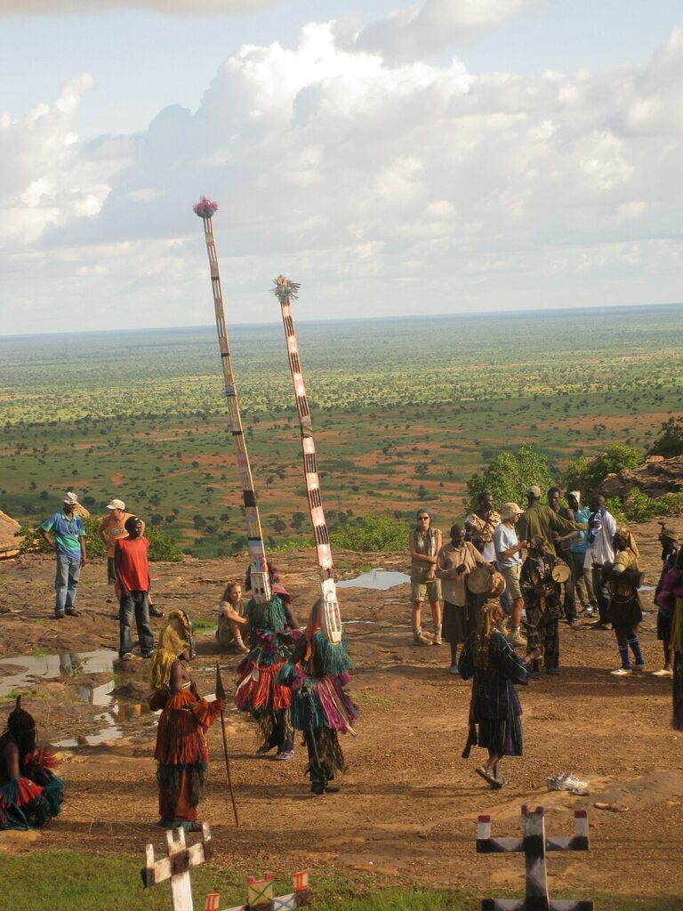
The Sigui festival and the problem of cycles

The Sigui is a vast ritual cycle with processions, masked dances, and renewal of social roles. Outsiders often compress it to a single number, then map that number onto an orbital period. Real life is messier. Communities adjust timing to social and historical needs, and the festival can run over several years. Linking it cleanly to a precise astronomical clock looks neat on paper. It does not match the full range of practice reported on the ground. This is exactly where long fieldwork helps. It records variation and keeps us from forcing ritual life into tidy graphs.

Dogon cosmology on its own terms

Dogon thought is rich without any appeal to impossible knowledge. Myths remember a first world that fractured, a creative word that shaped matter, and the difficult task of keeping order. Ancestors and masks fold those themes into daily life. Crafts carry meaning. Carved doors and posts tell stories in short, repeating signs. Divination tracks the pale fox, whose prints mark chance and choice. In this frame, stars matter as part of a whole. They join winds, animals, and seeds in a network of correspondences that tie the cliff to the sky.

Consider the granary. Its round plan and thatched cap have clear functions, yet people also read it as a model of the world. Seed inside suggests potential. The door carries signs that speak of protection, fertility, and time. A cosmology that uses grain and sky together is not naïve. It is practical poetry, built from things at hand.

How myths travel and shift

Knowledge is social. Traders, soldiers, teachers, and tourists pass through the Dogon country. Mission schools once taught European astronomy. Radios carried news in French and Bambara. A striking idea can land in a village and find a welcome place within an existing myth. Over time, borrowed details settle into local terms. The result is not fraud. It is culture at work. This is how myths everywhere grow and bend, whether in Rome, Benin, or Bamako.

That is why scholars care about dates and contexts. A detail recorded in 1931 carries different weight from one taped in 1970. A statement from a single expert differs from one confirmed across several elders from different villages. These distinctions feel fussy to casual readers, but they protect against turning a conversation into a creed.

Reading popular books with care

The “Sirius mystery” jumped from scholarly journals to mainstream shelves in the 1970s. Popularizers joined the dots in dramatic ways, sometimes bringing in extraterrestrials or ancient visitors. Reviews at the time noted how much of this rested on the early ethnographies and how little cross-checking had been done. For students, these episodes are useful. They show how fast a neat diagram can outrun the footnotes. The lesson is simple. Read the field reports. Then read the rest with curiosity and caution.

The landscape that holds the story

It helps to step back and look again at the cliff. Villages and shrines draw a line between rock and plain. Paths thread along the base. Granaries, male and female, punctuate the skyline. UNESCO’s listing remarks on the interplay of architecture, ritual, and landform, which is exactly what a visitor feels. In recent years, conflict in Mali has strained local life and damaged heritage. International projects have worked with communities to stabilise buildings and safeguard ceremonial objects. Cultural survival needs both peace and patient repair.

When people discuss the Dogon, they often jump straight to the star. The place itself deserves the first look. A cosmology grows in a setting, and the Bandiagara landscape explains much about Dogon priorities. Grain must be safe from mice and rain. Paths must manage steep ground. Meeting halls must shade speech. In that daily work, myth breathes.

What we can say clearly

First, the Dogon have a deep, layered cosmology that runs through craft, ritual, and story. Second, the most dramatic claims about secret knowledge of Sirius come from a specific strand of mid-century ethnography and do not appear widely in later field reports. Third, modern astronomy confirms that Sirius has a white dwarf companion with a long orbit, and modern images make it visible near the glare of the bright star. Fourth, it is sensible to keep the categories straight. Sky-lore and science meet at points, but they answer to different rules of evidence.

These points leave space for wonder without short-cuts. They also leave room for Dogon knowledge to stand as Dogon knowledge, not as proof of an exotic theory. Respect shows in details, and in patience with sources.

Why the story endures

It endures because it is tidy, dramatic, and flattering to readers who want mystery in every corner. It also endures because the Dogon are genuinely compelling. Their masks, architecture, and rites have power. A star gives outsiders an easy way in. Our job is to make sure the path leads to the people and their place, not just to a talking point.

Besides, the real questions are interesting enough. How do communities anchor memory over centuries. How do rites absorb change and still feel old. How do crafts teach children what a myth means. These questions connect the Dogon to everyone else. The answers are written in wood, fibre, millet, and song.

Seeing and reading the Dogon well

Good visits begin with local guides and time. A morning at the base of the cliff teaches more than a week of headlines. Granaries tell their own stories. Masks come alive when you hear the rattle and feel the ground jump. A quiet hour in a toguna explains how shade and short roofs keep tempers cool. Photographs are welcome in some places and not in others, and permission is key. Even from afar, open collections and museum catalogues offer strong images and careful notes that help readers see the difference between temper and fact.

Once you have that foundation, the sky talk becomes easier to place. Sirius is a bright point with a well-understood companion. The Dogon see the same sky the rest of us do. Their cosmology makes different use of it, binding star and seed into a single fabric. That is not a failure of science. It is the mark of a culture that knows how to think across domains.

Dogon mask dance with tall headdresses performed on the Sahel plains near the cliff
Dogon mask dance in Mali, part of funerary and cyclical rites such as the Sigui. Source: Wikimedia Commons

Putting the “mystery” back in context

Strip away the hype and you have a useful case study in how research works. One team records a complex system. Another team returns and finds a different picture. The community itself changes as decades pass. Global media lift a few lines and make them carry more weight than they can bear. Readers step in at different points and pick the version that suits their taste. The antidote is straightforward. Compare field reports. Note dates. Weigh methods. Keep the landscape and the people in the frame.

When you do, the Dogon look even more impressive. The question is no longer, “How did they know a white dwarf orbits Sirius.” It becomes, “How did they hold a living ritual system together across hard seasons and hard years.” That is a real achievement, and it belongs to them.

Hubble image showing bright Sirius A with faint white dwarf companion Sirius B
Hubble Space Telescope view of Sirius A and Sirius B. The pair orbit each other roughly every fifty years. Source: Wikimedia Commons / ESA/Hubble.

Granaries, stars, and the scale of meaning

One last image helps. Imagine a farmer unlocking a granary at dawn. The roof keeps out rain and heat. The walls keep out mice. Inside lies the next month’s food and seed for the next season. For the Dogon, that small tower also holds meanings that reach beyond the village. A seed can stand for beginnings. A door carving can fix a promise. A pattern can remember a story. Stars enter that field of signs and lend it a wider horizon. The meeting of the intimate and the immense is not strange here. It is the way the world holds together.

Octagonal Dogon granary with thatched cap in a village at the foot of the escarpment
Classic Dogon granary on stilts. Granaries store grain and symbolise protection, memory, and potential. Source: Wikimedia Commons.

A measured ending

Call it a mystery if you like, but do not stop at the slogan. The Dogon give us a chance to see how people build meaning from land, craft, and sky. They remind us that stories travel and that careful listening matters. They also invite us to enjoy a night under the Sahel stars with good company, where the bright point of Sirius rises over the cliff and the village settles into quiet. The sky is old. The questions are too. The answers are richer when we let the people who live with them speak first.

Dogon village of mud houses and granaries near the base of the Bandiagara escarpment
A Dogon village near the escarpment, showing earth architecture and the close link between settlement and landscape. Source: Wikimedia Commons.

Malta’s Cart Ruts: Prehistoric Parallel Grooves That Puzzle Archaeologists

Across Malta and Gozo, pairs of parallel grooves slice the rock as if the islands were scored with a giant’s comb. Locals call them cart ruts. Archaeologists prefer a cooler label, yet the effect is the same. Everywhere the limestone lies bare, you find twin tracks that swoop, split, cross, and sometimes seem to vanish over a cliff. The puzzle is familiar and still unsolved. What made them, when were they cut, and why do so many run together in dense clusters?

The fascination comes from scale as much as mystery. Thousands of metres of ruts survive. Some pairs keep a steady gauge. Others widen or taper. A few dig so deep that you can stand in them up to your knees. One field in the south of Malta is so busy with crossings that a British archaeologist nicknamed it Clapham Junction. He was thinking of a railway yard, packed with tracks, points, and switchbacks. That image stuck because it fits the scene.

What the ruts are, in practical terms

Each rut is a channel cut into the bedrock. The two in a pair run broadly parallel, with spacing that hovers around the width you would expect from a two-wheeled vehicle or a sledge with twin runners. Depth varies from a shallow groove to cuts more than half a metre deep. Profiles differ too. Some ruts have a neat U shape. Others carry a sharper V, especially where the limestone is hard. At junctions the grooves braid and diverge. In places they climb slopes so steep you wonder what load could ever have been hauled there without slipping.

The rock matters. Malta is built from limestones of different character. The soft Globigerina beds weather quickly when wet, while the Coralline units resist wear. That variation helps explain why ruts deepen in one place and barely mark another. It also feeds the debate about formation. If wheels or runners bit into a wet surface, the softer layers would yield first. Over time, repeated journeys might turn a faint track into a channel deep enough to steer the next traveller without effort.

Where to see them

To grasp the pattern, start at Misraħ Għar il-Kbir on the edge of the Dingli cliffs. The field there holds hundreds of intersecting grooves. Some run straight for a surprising distance. Others veer and pivot, as if the route was adjusted mid-journey. The scale makes the point. This was not a casual scratch or a one-off procession. It was a working landscape put to use again and again.

Next, cut across to San Ġwann and the Mensija ruts. Here the grooves weave through a now-urban setting. Seeing them in a neighbourhood makes their persistence real. Builders stepped around them. Paths curved to accommodate them. They are heritage patterns that stubbornly outlasted changing plans.

On Gozo, the Ta’ Ċenċ plateau carries fine examples above sheer cliffs. The openness of that landscape lets you watch the ruts ride the contours and then vanish towards the edge. North-east on Malta, the Xemxija Heritage Trail preserves a Punico-Roman road segment with clear channels underfoot. These are later in date than some prehistoric candidates, but they demonstrate how rock tracks behave when used over time. They also show how later travellers adopted old habits whenever bedrock dictated the route.

How old are they

Dating is the hardest part. Most ruts lack secure archaeological contexts. Many were exposed long after their creation, when soil eroded away. Researchers use indirect clues instead. At a few sites, ruts appear to pass beneath tombs or walls of known date, which sets a latest possible period for their formation. At others, tool marks and finds from nearby features hint at a broad window from the Temple Period through the Bronze Age and beyond.

That wide range may be the real answer. The islands saw long use of the same outcrops. One generation might mark a route lightly. Another, centuries later, could deepen the grooves while repeating the same path. In wet winters the rock softens and tyre-like loads bite more readily. In drier spells the surface hardens and wear slows. The result is a palimpsest, carved and re-carved by people who cared more about moving goods than leaving a tidy pattern for us to decipher.

What made them: the main ideas on the table

Several hypotheses compete, and each has strong points. One camp argues for wheeled carts with a standard axle width. Under heavy loads, and especially when the bedrock was damp, wooden wheels could cut a little deeper each season. Another view prefers sledges on twin runners. Runners loaded with stone would slide better than thick wheels when clay and limestone turned slick. A third suggestion pushes away from transport altogether. On that reading some grooves are deliberate furrows laid out to manage water or to extend thin arable soils across stubborn rock. Others point to quarrying. Chiselled channels could guide blocks from a cut face down towards a waiting track or jetty.

Evidence overlaps. Where wear is smooth and symmetrical, rolling contact remains plausible. Where the contact zone shows sharper tool marks, a sledge or pre-cut guide trough makes more sense. The islands were busy. There is no rule that says a single method must explain every track in every place. What unites the ideas is friction, weight, and repetition. However the movement happened, it happened often enough to bite the stone.

Close view of deep parallel grooves with steady gauge at Misraħ Għar il-Kbir
Cart ruts at Misraħ Għar il-Kbir showing depth and spacing that suggest repeated use. Source: Wikimedia Commons

What the measurements tell us

Systematic surveys have compared widths, depths, and profiles across dozens of sites. The pattern is tighter than first impressions suggest. Many ruts cluster around similar gauges. Depths vary, but the relationship between depth and shape tracks rock type. Where the limestone softens easily, U-shaped channels predominate. Where it resists, sharper V profiles hold. This coherence hints at regular practice. People were not improvising every time they moved a load. They followed established routes and reused widths that matched their equipment.

Calculations based on ground clearance make an elegant point. Imagine a cart with a modest axle and large wooden wheels. On a slippery slope, once the grooves deepened to the height of the axle, the cart would bottom out. The driver would be forced to shift to a new line beside the old one. That behaviour neatly explains the clusters at sites like Clapham Junction. Grooves come in sets because old channels eventually became too deep to use. The result looks like a rail yard because the landscape is full of retirements and replacements.

Why the ruts cross and wander

Crossings seem chaotic until you picture traffic management without engineered roads. In fields and quarry zones people would have wanted options. If one line turned slick, they could switch to a neighbouring path. If a block cracked and needed to be dumped, they would pull to one side. Slight changes in destination compound the effect. Even when routes head broadly the same way, a few degrees of difference at the start produce crossings further on.

The shape of the land matters again. Ridges funnel movement. Shallow basins collect water and become traps. The ruts circumambulate those hazards. Where the ground tilts, tracks climb diagonally to soften the gradient, then swing back. A map of the field becomes a tuition in invisible constraints, written in stone.

Do any run into the sea

Some coastal sites show grooves on the foreshore that now dip into shallow water. Local reports and older notes describe ruts that once ran further across the rock before modern building or erosion took them. It is tempting to link these to lower sea levels in the past or to gradual tilting of the islands. Both ideas have logic. So does a simpler thought. Shorelines move even on human timescales. A few centuries of storm damage and rockfall can alter the edge enough to interrupt tracks that originally stayed dry. Whatever the mechanism, the sight of twin channels disappearing below the waves has fed the popular imagination. It shows how close daily work once ran to water.

What site names reveal

The most famous field sits by a complex of caves known as Għar il-Kbir, “the big cave.” The nickname Clapham Junction is shorthand among guides, but the Maltese name keeps the landscape anchored in its real setting. Elsewhere the toponyms speak about agriculture and quarries. San Ġwann’s Mensija ruts run through a zone of fields and garden walls. The Xemxija road carries pilgrim crosses carved on the rock, reminders that later travellers repurposed earlier infrastructure. On Gozo, Ta’ Ċenċ sits high above the sea, with long views that explain why routes collected there. Names underline habits. People used the same places again and again because the ground told them to.

Cart ruts running through a suburban setting at Mensija
Mensija cart ruts at San Ġwann, with modern streets and walls respecting ancient grooves. Source: Wikimedia Commons

Science at work on an old question

Recent studies have brought geomorphology to bear on the problem. Researchers test how quickly limestone weakens when wet, how loads distribute across narrow wheels or runners, and how slope and surface texture accelerate wear. They model the forces needed to produce observed depths within realistic timeframes. They also compare rut shapes across the islands to see whether the same types recur in different settings. Together these methods move the debate away from arm-waving towards numbers that can be checked.

Alongside this, archaeologists revisit old field notes and photographs. Some early excavations captured ruts partly buried under soil. Those records give a sense of how much erosion has changed the sites since. They also help tie particular grooves to nearby tombs, walls, and tool marks, which nudges the dating a little closer.

Transport, fields, or a bit of both

It may be fruitful to stop asking for a single answer. In a small island landscape, tasks crowd together. Quarrying, hauling, farming, and ritual passages could all mark the same outcrop at different times. A shallow groove used to channel run-off might have made a perfect guide for a sledge once the season turned. A block path cut to move stone might have doubled as a route for the heavy jars and amphorae that supplied a nearby site. When communities reuse the same ground for centuries, boundaries between functions blur.

The best approach is to read each field on its own merits. Does the rut emerge from a quarry face or aim towards one. Do grooves step neatly down a slope with consistent spacing, which suits controlled descent. Are there signs of chisel work within the channels. Do nearby features match a farmed landscape, such as small field systems and water management. Answers will differ site by site, and that is not a weakness. It is how living landscapes behave.

Twin grooves on the Ta’ Ċenċ plateau near the cliff edge
Cart ruts riding the contours on the Ta’ Ċenċ plateau, with a dramatic drop nearby. Source: Wikimedia Commons

Visiting well and reading the ground

The sites are open, windswept, and deceptively delicate. Bedrock shows wear from every modern footstep. Try to keep to obvious paths and avoid walking inside the deeper channels. After rain the rock turns slick and fragile. This is also when the ruts look their clearest, as water pools in the grooves and makes their pattern show. Early light helps. Shadows draw sharp lines that reveal intersections you might miss at midday.

Bring a simple checklist. Watch for a steady gauge between the grooves. Note where one pair widens or narrows. Look at the profile: U or V. Trace the route up and down the slope. Where does it choose to cross a ridge. Where does it dodge a shallow hollow that would hold winter water. In a few minutes you will find yourself reading a path from the point of view of the person who last hauled a load along it. That shift is the gift these sites offer.

Why the ruts matter now

They are not only a curiosity for guidebooks. They are part of a long story of work, habit, and adaptation. The tracks remind us that infrastructure does not always look like a paved road. Sometimes it is a pair of grooves that quietly steer a community’s labour across a rocky slope. They also act as a shared archive. Farmers, quarrymen, carters, and pilgrims left their mark in the same stone. The result is a common text written over centuries in a script that takes patience to learn.

For Malta and Gozo, the ruts form a thread that ties prehistoric settlement to later urban life. They cross parish boundaries and municipal zones without caring about them. They show how the islands’ geology shaped movement, how weather narrowed choices, and how people found efficient routes that we can still trace today. You do not need to agree on a single origin story to feel their importance. Standing in one of the deeper pairs and looking along its line is enough.

Rock-cut grooves on the Punico-Roman road at Xemxija
A Roman-period road segment on the Xemxija Heritage Trail preserves clear grooves from prolonged traffic. Source: Wikimedia Commons

Questions worth taking forward

Several lines of enquiry look promising. First, more fine-grained measurement. Cheap 3D scanning can capture rut profiles and depths at thousands of points, letting researchers compare sites precisely. Second, targeted excavation at the edges of fields where shallow soil still covers the rock. Finds trapped in that layer could fix dates for first use or latest reuse. Third, experimental archaeology that matches local limestone, reconstructed carts or sledges, and controlled loads. Trials on short test beds would show how quickly grooves form under realistic conditions.

There is also room for landscape history. Many tracks now end abruptly at modern walls or roads. Old aerial photographs and nineteenth-century plans can reveal how lines continued before development. In a few cases, geophysical methods might trace ruts where thin colluvium hides them. A joined-up map would help explain why routes favour one pass over another and how sets relate across hillsides.

A measured closing thought

These grooves do not need a single dramatic explanation to be worth our attention. Their power lies in accumulation. Step after step, wheel after wheel, runner after runner, they turned stubborn ground into a guide. The pattern looks chaotic from a distance. Up close it reads like sense, pressed into stone by people who knew exactly what they were doing. That is the part that lingers when you walk away. The island keeps its lines, and the lines keep their stories.