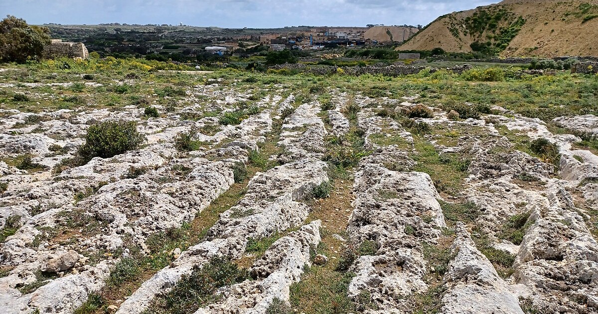
Across Malta and Gozo, pairs of parallel grooves slice the rock as if the islands were scored with a giant’s comb. Locals call them cart ruts. Archaeologists prefer a cooler label, yet the effect is the same. Everywhere the limestone lies bare, you find twin tracks that swoop, split, cross, and sometimes seem to vanish over a cliff. The puzzle is familiar and still unsolved. What made them, when were they cut, and why do so many run together in dense clusters?
The fascination comes from scale as much as mystery. Thousands of metres of ruts survive. Some pairs keep a steady gauge. Others widen or taper. A few dig so deep that you can stand in them up to your knees. One field in the south of Malta is so busy with crossings that a British archaeologist nicknamed it Clapham Junction. He was thinking of a railway yard, packed with tracks, points, and switchbacks. That image stuck because it fits the scene.
What the ruts are, in practical terms
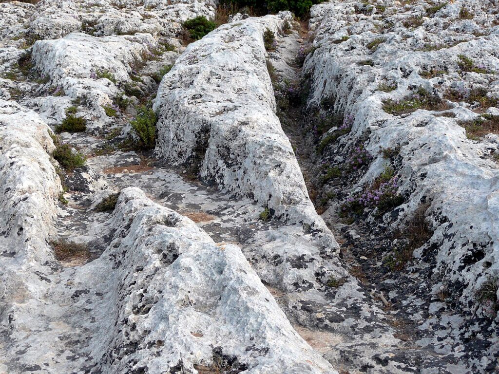
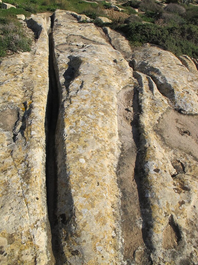
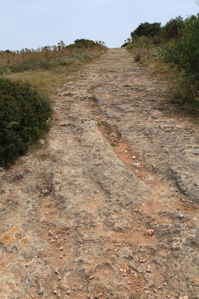
Each rut is a channel cut into the bedrock. The two in a pair run broadly parallel, with spacing that hovers around the width you would expect from a two-wheeled vehicle or a sledge with twin runners. Depth varies from a shallow groove to cuts more than half a metre deep. Profiles differ too. Some ruts have a neat U shape. Others carry a sharper V, especially where the limestone is hard. At junctions the grooves braid and diverge. In places they climb slopes so steep you wonder what load could ever have been hauled there without slipping.
The rock matters. Malta is built from limestones of different character. The soft Globigerina beds weather quickly when wet, while the Coralline units resist wear. That variation helps explain why ruts deepen in one place and barely mark another. It also feeds the debate about formation. If wheels or runners bit into a wet surface, the softer layers would yield first. Over time, repeated journeys might turn a faint track into a channel deep enough to steer the next traveller without effort.
Where to see them
To grasp the pattern, start at Misraħ Għar il-Kbir on the edge of the Dingli cliffs. The field there holds hundreds of intersecting grooves. Some run straight for a surprising distance. Others veer and pivot, as if the route was adjusted mid-journey. The scale makes the point. This was not a casual scratch or a one-off procession. It was a working landscape put to use again and again.
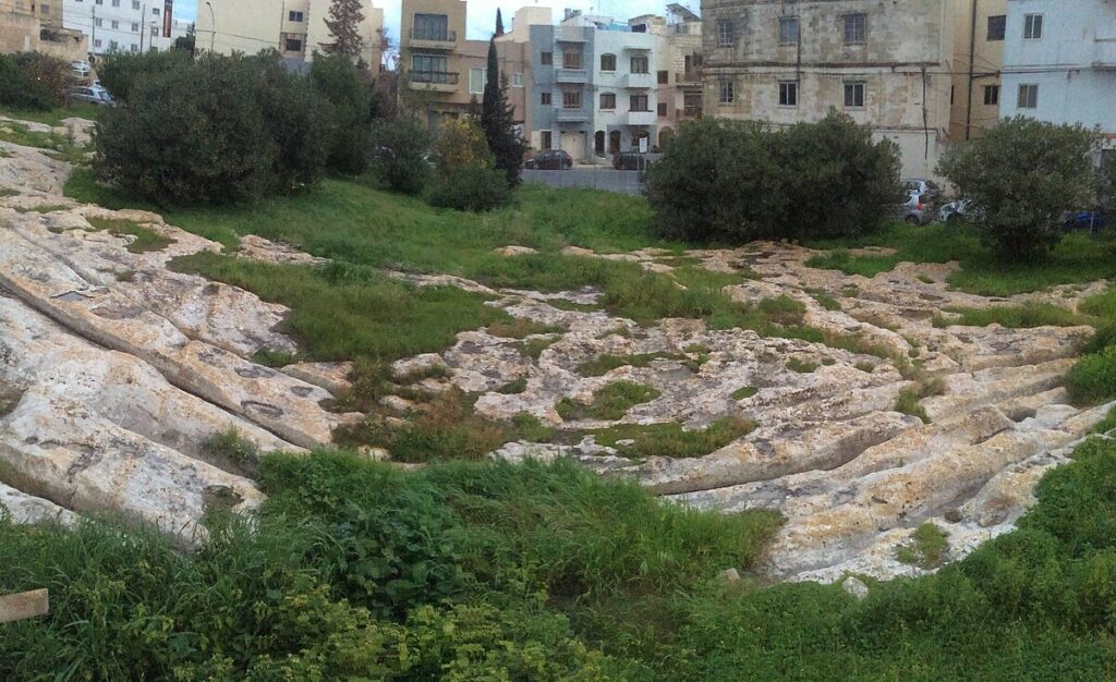
Next, cut across to San Ġwann and the Mensija ruts. Here the grooves weave through a now-urban setting. Seeing them in a neighbourhood makes their persistence real. Builders stepped around them. Paths curved to accommodate them. They are heritage patterns that stubbornly outlasted changing plans.
On Gozo, the Ta’ Ċenċ plateau carries fine examples above sheer cliffs. The openness of that landscape lets you watch the ruts ride the contours and then vanish towards the edge. North-east on Malta, the Xemxija Heritage Trail preserves a Punico-Roman road segment with clear channels underfoot. These are later in date than some prehistoric candidates, but they demonstrate how rock tracks behave when used over time. They also show how later travellers adopted old habits whenever bedrock dictated the route.
How old are they
Dating is the hardest part. Most ruts lack secure archaeological contexts. Many were exposed long after their creation, when soil eroded away. Researchers use indirect clues instead. At a few sites, ruts appear to pass beneath tombs or walls of known date, which sets a latest possible period for their formation. At others, tool marks and finds from nearby features hint at a broad window from the Temple Period through the Bronze Age and beyond.
That wide range may be the real answer. The islands saw long use of the same outcrops. One generation might mark a route lightly. Another, centuries later, could deepen the grooves while repeating the same path. In wet winters the rock softens and tyre-like loads bite more readily. In drier spells the surface hardens and wear slows. The result is a palimpsest, carved and re-carved by people who cared more about moving goods than leaving a tidy pattern for us to decipher.
What made them: the main ideas on the table
Several hypotheses compete, and each has strong points. One camp argues for wheeled carts with a standard axle width. Under heavy loads, and especially when the bedrock was damp, wooden wheels could cut a little deeper each season. Another view prefers sledges on twin runners. Runners loaded with stone would slide better than thick wheels when clay and limestone turned slick. A third suggestion pushes away from transport altogether. On that reading some grooves are deliberate furrows laid out to manage water or to extend thin arable soils across stubborn rock. Others point to quarrying. Chiselled channels could guide blocks from a cut face down towards a waiting track or jetty.
Evidence overlaps. Where wear is smooth and symmetrical, rolling contact remains plausible. Where the contact zone shows sharper tool marks, a sledge or pre-cut guide trough makes more sense. The islands were busy. There is no rule that says a single method must explain every track in every place. What unites the ideas is friction, weight, and repetition. However the movement happened, it happened often enough to bite the stone.
What the measurements tell us
Systematic surveys have compared widths, depths, and profiles across dozens of sites. The pattern is tighter than first impressions suggest. Many ruts cluster around similar gauges. Depths vary, but the relationship between depth and shape tracks rock type. Where the limestone softens easily, U-shaped channels predominate. Where it resists, sharper V profiles hold. This coherence hints at regular practice. People were not improvising every time they moved a load. They followed established routes and reused widths that matched their equipment.
Calculations based on ground clearance make an elegant point. Imagine a cart with a modest axle and large wooden wheels. On a slippery slope, once the grooves deepened to the height of the axle, the cart would bottom out. The driver would be forced to shift to a new line beside the old one. That behaviour neatly explains the clusters at sites like Clapham Junction. Grooves come in sets because old channels eventually became too deep to use. The result looks like a rail yard because the landscape is full of retirements and replacements.
Why the ruts cross and wander
Crossings seem chaotic until you picture traffic management without engineered roads. In fields and quarry zones people would have wanted options. If one line turned slick, they could switch to a neighbouring path. If a block cracked and needed to be dumped, they would pull to one side. Slight changes in destination compound the effect. Even when routes head broadly the same way, a few degrees of difference at the start produce crossings further on.
The shape of the land matters again. Ridges funnel movement. Shallow basins collect water and become traps. The ruts circumambulate those hazards. Where the ground tilts, tracks climb diagonally to soften the gradient, then swing back. A map of the field becomes a tuition in invisible constraints, written in stone.
Do any run into the sea
Some coastal sites show grooves on the foreshore that now dip into shallow water. Local reports and older notes describe ruts that once ran further across the rock before modern building or erosion took them. It is tempting to link these to lower sea levels in the past or to gradual tilting of the islands. Both ideas have logic. So does a simpler thought. Shorelines move even on human timescales. A few centuries of storm damage and rockfall can alter the edge enough to interrupt tracks that originally stayed dry. Whatever the mechanism, the sight of twin channels disappearing below the waves has fed the popular imagination. It shows how close daily work once ran to water.
What site names reveal
The most famous field sits by a complex of caves known as Għar il-Kbir, “the big cave.” The nickname Clapham Junction is shorthand among guides, but the Maltese name keeps the landscape anchored in its real setting. Elsewhere the toponyms speak about agriculture and quarries. San Ġwann’s Mensija ruts run through a zone of fields and garden walls. The Xemxija road carries pilgrim crosses carved on the rock, reminders that later travellers repurposed earlier infrastructure. On Gozo, Ta’ Ċenċ sits high above the sea, with long views that explain why routes collected there. Names underline habits. People used the same places again and again because the ground told them to.
Science at work on an old question
Recent studies have brought geomorphology to bear on the problem. Researchers test how quickly limestone weakens when wet, how loads distribute across narrow wheels or runners, and how slope and surface texture accelerate wear. They model the forces needed to produce observed depths within realistic timeframes. They also compare rut shapes across the islands to see whether the same types recur in different settings. Together these methods move the debate away from arm-waving towards numbers that can be checked.
Alongside this, archaeologists revisit old field notes and photographs. Some early excavations captured ruts partly buried under soil. Those records give a sense of how much erosion has changed the sites since. They also help tie particular grooves to nearby tombs, walls, and tool marks, which nudges the dating a little closer.
Transport, fields, or a bit of both
It may be fruitful to stop asking for a single answer. In a small island landscape, tasks crowd together. Quarrying, hauling, farming, and ritual passages could all mark the same outcrop at different times. A shallow groove used to channel run-off might have made a perfect guide for a sledge once the season turned. A block path cut to move stone might have doubled as a route for the heavy jars and amphorae that supplied a nearby site. When communities reuse the same ground for centuries, boundaries between functions blur.
The best approach is to read each field on its own merits. Does the rut emerge from a quarry face or aim towards one. Do grooves step neatly down a slope with consistent spacing, which suits controlled descent. Are there signs of chisel work within the channels. Do nearby features match a farmed landscape, such as small field systems and water management. Answers will differ site by site, and that is not a weakness. It is how living landscapes behave.
Visiting well and reading the ground
The sites are open, windswept, and deceptively delicate. Bedrock shows wear from every modern footstep. Try to keep to obvious paths and avoid walking inside the deeper channels. After rain the rock turns slick and fragile. This is also when the ruts look their clearest, as water pools in the grooves and makes their pattern show. Early light helps. Shadows draw sharp lines that reveal intersections you might miss at midday.
Bring a simple checklist. Watch for a steady gauge between the grooves. Note where one pair widens or narrows. Look at the profile: U or V. Trace the route up and down the slope. Where does it choose to cross a ridge. Where does it dodge a shallow hollow that would hold winter water. In a few minutes you will find yourself reading a path from the point of view of the person who last hauled a load along it. That shift is the gift these sites offer.
Why the ruts matter now
They are not only a curiosity for guidebooks. They are part of a long story of work, habit, and adaptation. The tracks remind us that infrastructure does not always look like a paved road. Sometimes it is a pair of grooves that quietly steer a community’s labour across a rocky slope. They also act as a shared archive. Farmers, quarrymen, carters, and pilgrims left their mark in the same stone. The result is a common text written over centuries in a script that takes patience to learn.
For Malta and Gozo, the ruts form a thread that ties prehistoric settlement to later urban life. They cross parish boundaries and municipal zones without caring about them. They show how the islands’ geology shaped movement, how weather narrowed choices, and how people found efficient routes that we can still trace today. You do not need to agree on a single origin story to feel their importance. Standing in one of the deeper pairs and looking along its line is enough.
Questions worth taking forward
Several lines of enquiry look promising. First, more fine-grained measurement. Cheap 3D scanning can capture rut profiles and depths at thousands of points, letting researchers compare sites precisely. Second, targeted excavation at the edges of fields where shallow soil still covers the rock. Finds trapped in that layer could fix dates for first use or latest reuse. Third, experimental archaeology that matches local limestone, reconstructed carts or sledges, and controlled loads. Trials on short test beds would show how quickly grooves form under realistic conditions.
There is also room for landscape history. Many tracks now end abruptly at modern walls or roads. Old aerial photographs and nineteenth-century plans can reveal how lines continued before development. In a few cases, geophysical methods might trace ruts where thin colluvium hides them. A joined-up map would help explain why routes favour one pass over another and how sets relate across hillsides.
A measured closing thought
These grooves do not need a single dramatic explanation to be worth our attention. Their power lies in accumulation. Step after step, wheel after wheel, runner after runner, they turned stubborn ground into a guide. The pattern looks chaotic from a distance. Up close it reads like sense, pressed into stone by people who knew exactly what they were doing. That is the part that lingers when you walk away. The island keeps its lines, and the lines keep their stories.